Unplanned TTC bus and streetcar diversions now tracked in real-time in Transit app
Customers who use the Transit app to plan their trip or see bus and streetcar arrival times, can now see, in real-time, if the vehicle is travelling off its regular route due to on-street emergencies, extreme weather, construction or other unplanned events.
The TTC has partnered with Transit to pilot its bus and streetcar detour feature, making it easier for customers to plan their trip in advance or adjust their travel along the way. All bus and streetcar routes are part of this 12-month pilot.
How Transit app detour detection works
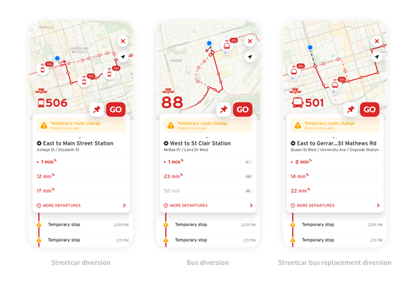
Transit will detect and display detours on a bus or streetcar route after a vehicle has made three consecutive trips off the route. The section of the route that is not being serviced during the detour will be marked with dashed lines and closed stops will be shown on the map with an “x” icon. It also works on streetcar routes that have been replaced with buses!
Once the vehicle has completed one trip back on its regular route, the detour will be removed.
Transit app is the only place customers can see this information. The app can be downloaded for free from Google Play on Android or the App Store on IOS.
In the app, customers can select a route by clicking on it, the route map will appear and it will show where the vehicle is, when its scheduled to arrive, how crowded it is, whether it is travelling on its regular route or has diverted from the route and where the temporary stops are located, if it’s no longer on its original route. Customer can share their feedback through Transit’s app Contact Us feature in the app.